Rainfall severity getting worse
Higher estimate for 100-year storm could affect development
By Mihir Zaveri
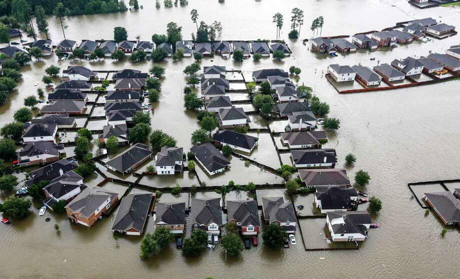
More than three months after Hurricane Harvey battered Southeast Texas with unprecedented and costly flooding, an analysis of rainfall trends across Texas suggests the standards used to develop flood plain regulations, map flood zones and design flood control projects routinely underestimate the severity of the Houston area’s downpours.
That analysis by the National Oceanic and Atmospheric Association, which looked at rainfall data stretching back decades, up to and including Harvey, shows the amount of rain that defines a “100-year storm” — one that has a 1percent chance of occurring in any given year — has risen by 3 to 5 inches in Harris County since the last estimates were put in place in 2002.
Instead of expecting 12 to 14 inches in a day during a100-year storm, the data shows the county should expect 15 to 18 inches.
A higher rainfall estimate for a 100-year storm means developers would need to design subdivisions and strip malls to compensate for higher runoff, and more existing residential and business properties would be included in new flood plain maps that drive insurance costs and development regulations.
“We design our infrastructure and our society and homes to be resilient to a certain level of risk,” said John Nielsen-Gammon, the Texas state climatologist and professor of atmospheric science at Texas A&M University. “Having updated, more accurate numbers means that we’re better able to do that, and the risk we’re undertaking matches the risk we’re designing for.”
The final NOAA data will be published in May 2018, the first statewide update to the federal agency’s rainfall estimates in nearly 50 years. The preliminary data will be available for comment until Jan. 19.
In the aftermath of Harvey, the third at-least “500-year” storm to hit Houston in as many years, many suggested the estimates used to model and predict extreme rainfall here were inadequate.
The data from NOAA’s study, while not final, appears to bolster that argument. If NOAA’s results hold through peer review, they would mean local flood plain maps are not big enough and development regulations are not strict enough to compensate for the storms they are nominally designed to handle.
“It would change how infrastructure is designed, for example, channels might have to be bigger. Detention basins would have to be larger. Bridges and culverts would have to be larger. Land plans for new development would change. Obviously, there would be more land required for mitigation, less land allowed for development,” said Matt Zeve, director of operations at the Harris County Flood Control District. “It’s a big deal, it’s going to affect people that don’t even know that they will be affected.”
NOAA’s release of the preliminary data comes as the Houston region continues to recover from Harvey’s devastation. The storm dumped more than 51 inches of rain in the county, flooded hundreds of thousands of homes, apartment units and businesses and killed upwards of 80 people in the state.
Strategy sessions
Harvey, along with the Tax Day 2016 floods, and the Memorial Day 2015 floods, have prompted local officials to consider a series of ideas to revamp the flood control strategy around Houston.
This month, the county proposed a set of vastly expanded regulations for new development in flood plains, including a requirement that developers build new homes up to 8 feet higher than previously required in some areas, as well as regulating, for the first time, in 500-year flood plains instead of 100-year flood plains — broader geographic areas around bayous and creeks. Harris County Commissioners Court could vote to approve those regulations as early as Dec. 5.
Harris County Judge Ed Emmett has proposed 15 measures to improve flood control efforts, including the construction of a third dam and reservoir system in the northwest part of the county, widespread buyouts of flood-prone homes and an effort to push the state to give Harris County the authority to levy a sales tax to pay for costly flood control measures. A majority of Commissioners Court has indicated it would support a bond referendum, possibly upwards of $1 billion, for flood control.
Most of the other efforts focus on responding to and managing floodwaters, but the NOAA study has been the main ongoing effort to improve the understanding of the science behind storms.
The flood control district contributed $200,000 to fund the study in February 2016. Other agencies are funding the NOAA effort in Texas.
Large sample size
Michael St. Laurent, a meteorologist with NOAA, said the agency analyzed decades worth of data from rain gauges across Texas, some dating to the 1800s. He said the agency collected data down to the hourly and 15-minute intervals from some gauges.
The Texas study is part of a nationwide look at rainfall frequency, the first by NOAA since 1961. The study has been ongoing since 2004.
The preliminary data released last week includes estimates across Texas. A broad swath of Texas, stretching from Beaumont and Port Arthur, across Austin and the middle of the state, and all the way to Del Rio, indicates rainfall greater than that modeled during the 1961 study. In some parts of west Texas, the data shows the amount of rainfall indicating a 100-year storm should actually be lower than current standards.
St. Laurent said the increase in the 100-year storm severity for the Houston area could be attributed in part to the several severe storms the region had experienced since 2002. NOAA included data from Harvey in its analysis.
“The additional decade or two of data have some significantly high rainfall events that definitely contribute to higher precipitation estimates,” he said.
Nielsen-Gammon, the state climatologist, said any time officials have more data with which to work, estimates change, particularly when including events like the Tax Day flood and Harvey. The new estimates, he added, also reflect a changing climate.
“You wouldn’t want to look at an individual location and say that all of the change there is due to climate change,” Nielsen-Gammon said. “But if you look at the state as a whole, it seems that the increases have outnumbered the decreases, at least in the current draft. So, that’s some combination of longer-term natural variability and climate change that’s doing that.”
The rainfall analysis promises to have significant local impacts.
For example, in Harris County, regulations force developers to use the 100-year storm estimate to offset the impact of paving over flood-absorbent ground. Any development — subdivision, strip mall, gas station — must build a basin that holds runoff and releases it slowly so as to not increase flooding downstream, based on how much it would rain during the 100-year storm.
If the 100-year storm estimate increases, regulations would force developers to hold more water than before.
In another example, flood plain maps are drawn by modeling how rainfall would spill out of bayous, creeks and ditches in the event of a 100-year storm. If that standard goes up, the flood plains would expand, and likely mean higher insurance rates for those newly in flood plains and stricter regulations in those areas.
“You’re going to see a lot more structures added to the flood plain, and they’re going to be required to buy flood insurance,” said Larry Larson, senior policy analyst with the Association of State Floodplain Managers.
Flood plains to be redrawn
Zeve said the district was determining how to open talks with FEMA about how to redraw floodplains in the county, and who would pay for what could be a multimillion-dollar effort.
“Obviously, the numbers are going to go up, it’s probably going to be significant,” Zeve said. “Now is the time for us to start planning for how to deal with it.
Alan Bernstein, spokesman for Mayor Sylvester Turner, called the NOAA preliminary data “valuable input.” He said he data “will be considered along with reports and data from many such trusted sources as Mayor Turner and all of city government work to build a more resilient, flood-minimizing Houston in the post-Harvey era, with long-term public safety as the top priority.”
Still Zeve emphasized the data was preliminary, and could undergo changes before it is finalized in May.
“Anything could happen,” he said. “Someone could review the information and find a glaring error. We don’t know. But that’s the whole point of having people check each other’s work, the quality control process is important on any big scientific effort.”
Mike Morris contributed to this report. mihir.zaveri@chron.com twitter.com/mihirzaveri
“It would change how infrastructure is designed. … Land plans for new development would change. Obviously, there would be more land required for mitigation, less land allowed for development.”
Matt Zeve, Harris County Flood Control District
Reprint from Houston Chronicle